Land
How Are We Improving Floodplain Health in the Puyallup Watershed?
We are learning how our communities interact with land in the floodplain
FFTF partners seek to understand the extent and changes in land floodplain land uses such as agriculture, floodplain restoration, public access, and development as a measure of the cumulative impact of policies, programs, and capital investments in integrated floodplain management.
Built Environment in the Floodplain
This metric tracks changes in land-use in the floodplain using the Washington Department of Fish and Wildlife’s High Resolution Change Detection (HRCD) data. This dataset quantifies canopy loss, tracks changes in the amount of impervious and semi-impervious surfaces and provides information as to the likely cause of change, allowing FFTF partners to better understand interactions between communities and land in the floodplain. HRCD data is highly accurate and able to detect changes as small as 1/20th of an acre. “Built Environment” is defined as human dominated land cover such as roads, buildings, and warehouses.
FFTF Goal(s):
All Goals
Baseline Year:
2013-2015
Status:
Baseline results established in 2019
Source(s):
Washington Department of Fish and Wildlife – High Resolution Change Detection Dataset
- 2013-2015 Result: 350 acres of new built environment in the floodplain.
- 2015-2017 Result: 250 acres of new built environment in the floodplain.

Actively Farmed Land
This metric tracks the amount of actively farmed land in the Puyallup watershed using Washington State Department of Agriculture land use mapping data merged with Current Use Agriculture parcels from the Pierce County Assessor.
FFTF Goal(s):
- Protect/conserve agricultural lands
- Maintain viable farming economy/critical mass of farmland and farm businesses
Baseline Year:
2013
Status:
Baseline results established in 2019
Source(s):
- Washington State Department of Agriculture: Land-use mapping data
- Pierce County Assessor: Current use agriculture parcels
- 2013 Result: 4,157 acres of actively farmed land in the floodplain planning area.
- 2019 Result: 3,905 acres of actively farmed land in the floodplain planning area.
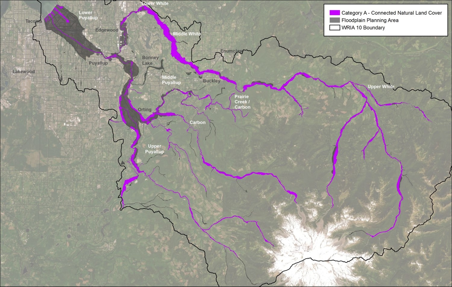
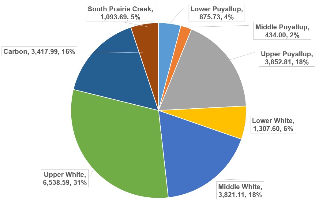
Connected/Natural Floodplain
This metric tracks floodplain areas that are connected to the river or a tributary (i.e. do not have a levee, road, or other barrier between the floodplain and the river) and have natural land cover.
FFTF Goal(s):
- Protect existing functional salmon habitat
- Increase the resilience of flood management infrastructure, the ecosystem, and agriculture as climate changes
Baseline Year:
2013
Status:
Baseline results established in 2019
Source(s):
Washington Department of Fish and Wildlife: High Resolution Land Cover Dataset
- 2013 Result: 21,078 acres of connected floodplain with natural land cover.
- 2015 Result: 21,217 acres of connected floodplain with natural land cover.
- 2017 Result: 21,334 acres of connected floodplain with natural land cover.
Weather and Climate Conditions
This metric tracks six aspects of weather and climate conditions using gauges and historical records from within the Floodplain Planning Area.
- Air Temperature
- Heavy Rainfall Events
- Snowpack
- April 1 Snow Water Equivalent (SWE)
- Lower Elevation SWE
- Streamflow
- Peak Streamflow
- 2-Year Streamflow
- Low Streamflow
- Water Temperature
- Air Quality
FFTF Goal(s):
- Protect existing functional salmon habitat
- Increase the resilience of flood management infrastructure, the ecosystem, and agriculture as climate changes
Baseline Year:
2013
Status:
Baseline results established in 2019
Source(s):
Washington Department of Fish and Wildlife: High Resolution Land Cover Dataset
- Air Temperature 2020 Result: 12 days above 85 degrees. 3 days above 90 degrees
- Heavy Rainfall Events 2020 Result: 4 days where precipitation exceeded 1 inch
- April 1 SWE 2020 Result: SWE on April 1 was 24.3 inches
- Lower Elevation SWE 2020 Result: Maximum SWE was 3.3 inches on 1/23
- Peak Streamflow Water Year 2020 Result: 39,500 CFS peak at the Puyallup gauge (February 7, 2020)
- 2-year Streamflow 2020 Result: 3 days with streamflow above the two-year flow threshold (21,500 CFS)
- Low Streamflow 2020 Result: Lowest 7-day Average Streamflow at the Puyallup River Gauge was 1,370 CFS from 10/3 – 10/9
- Water Temperature 2020 Result: The highest 7-day average daily maximum water temperature at the White River gauge was 19 degrees Celsius
- Air Quality 2020 Result: 7 days with Particulate Matter (PM) 2.5 concentrations above 55.5 µg/m3. Average concentration was 102.4 µg/m3
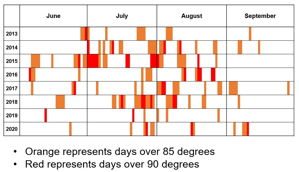
2020 Result: 12 days above 85 degrees, 3 days above 90 degrees
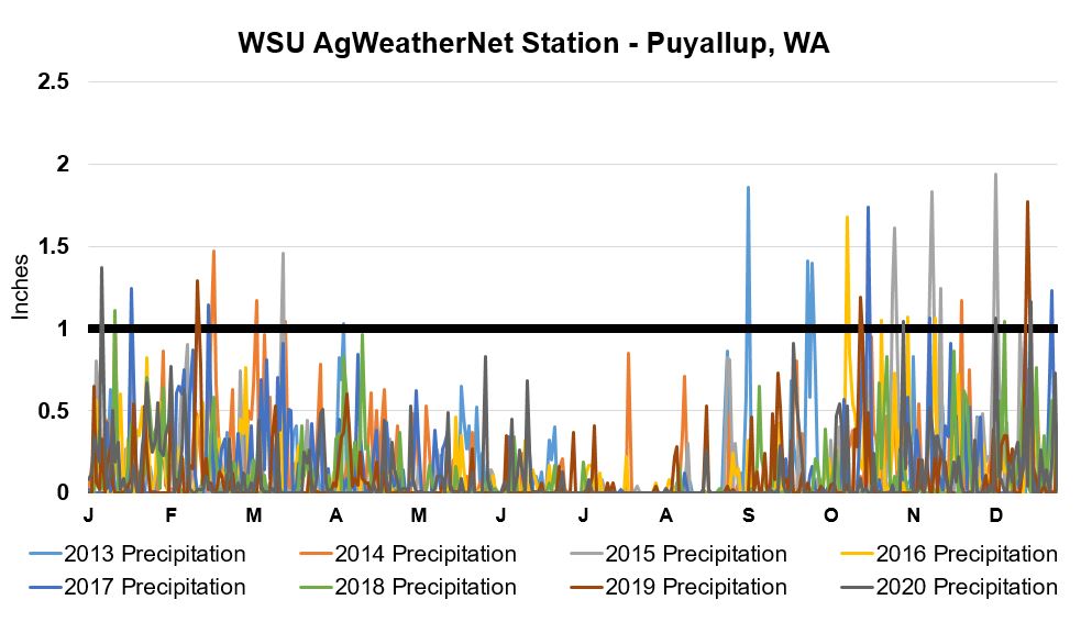
2020 Result: 4 days where precipitation exceeded 1 inch. The black line is used to show days with greater than 1 inch of precipitation.

2020 Result: SWE on April 1 was 24.3 inches. Graph displays annual snow water equivalent (SWE) on April 1st at the Burnt Mountain Gauge (4,170 feet). "Blob", "ño", and "ña" indicate years in which the blob of warm water in the Pacific, El Niño, and La Niña occurred, respectively.
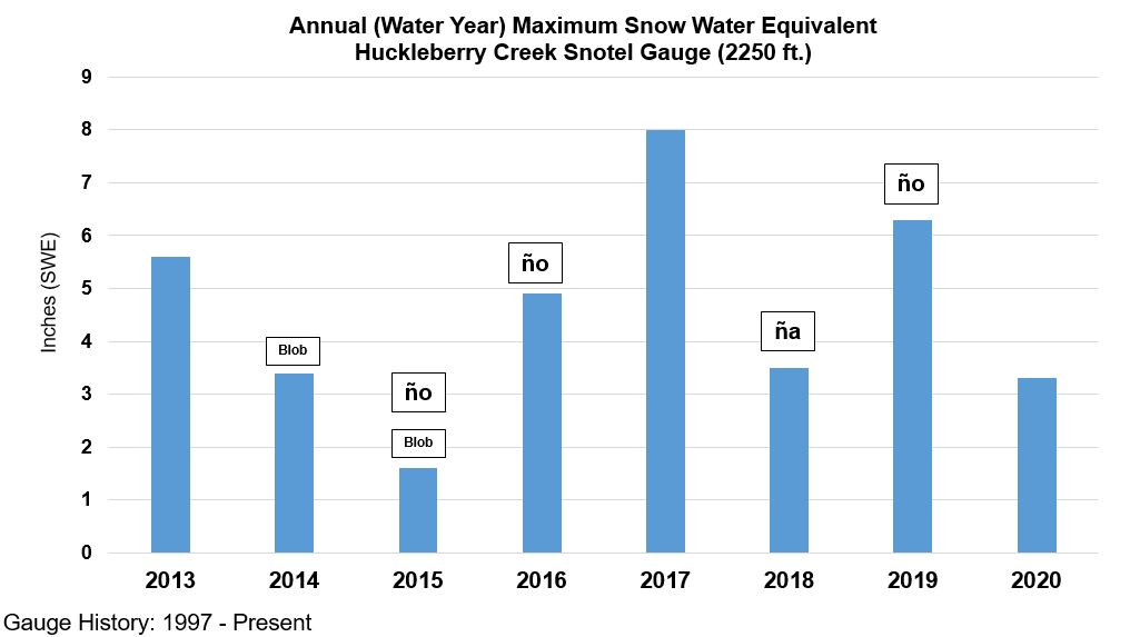
2020 Result: Maximum SWE was 3.3 inches on 1/23. Graph displays results of the annual maximum Lower Elevation SWE at the Huckleberry Gauge (2,250 feet). "Blob", "ño", and "ña" indicate years in which the blob of warm water in the Pacific, El Niño, and La Niña occurred, respectively.

Graph shows the date at which the annual maximum SWE occurred at the lower elevation gauge. "Blob", "ño", and "ña" indicate years in which the blob of warm water in the Pacific, El Niño, and La Niña occurred, respectively.
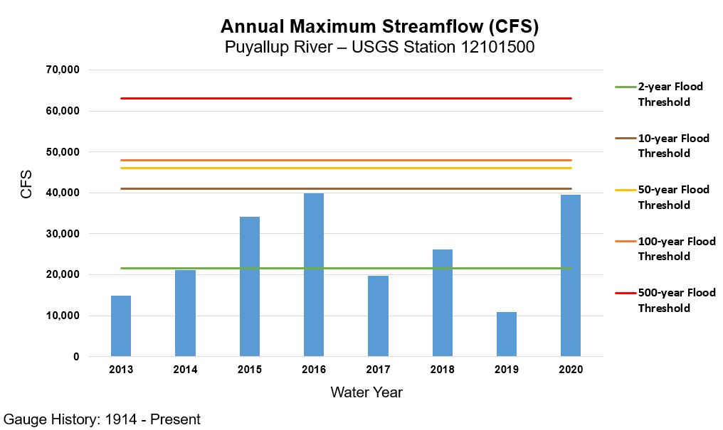
2020 Result: 39,500 cfs peak streamflow a the Puyallup gauge (February 7th, 2020)
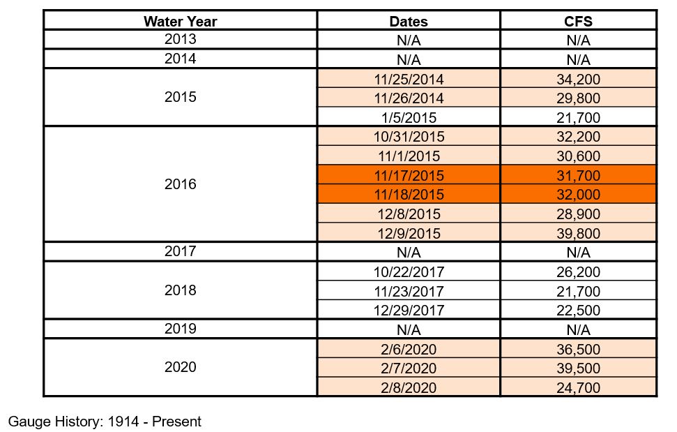
2020 Result: 3 days with streamflow above the two-year flow threshold (21,500 cfs). Table displays the dates at which flow levels exceeded the 2-year flood threshold (21,500 cfs) at the Puyallup River gauge. Highlighted entries indicate consecutive days.

2020 Result: Lowest 7-day average streamflow at the Puyallup River gauge was 1370 cfs from 10/3 - 10/9. "Blob", "ño", and "ña" indicate years in which the blob of warm water in the Pacific, El Niño, and La Niña occurred, respectively.

2020 Result: The highest 7-day average daily maximum water temperature at the White River gauge was 19 degrees C
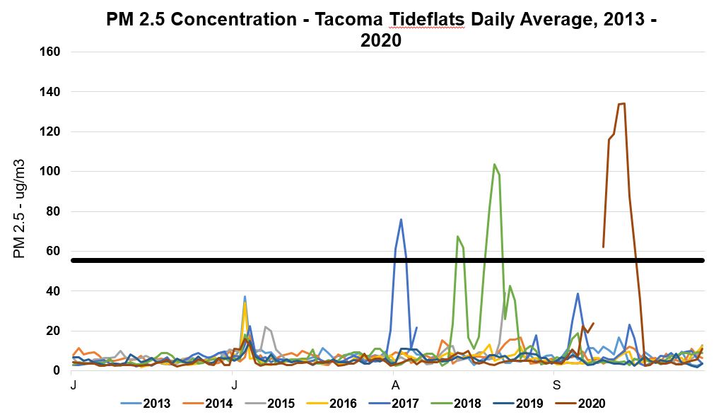
2020 Result: 7 days with PM 2.5 concentrations above 55.5 µg/m3. Average concentration 102.4 µg/m3. Black line represents 55µg/m^3, the particulate matter (PM) 2.5 value above which air quality is considered unhealthy for all groups.
Accessible Stream Miles
The amount of accessible stream miles is critical to the health of salmonids in the Puyallup watershed. Barriers, such as culverts, can significantly restrict the amount of available habitat for salmon to spawn and feed. This metric will track the amount of stream impediments and quantify the amount of accessible stream miles in the watershed.
FFTF Goal(s):
- Restore historic function for spawning, foraging, and rearing habitat
- Increase salmon abundance
Baseline Year:
2013
Status:
None to report; baseline information to be established in 2021.
Source(s):
Washington Department of Fish and Wildlife
Data for this metric will be reported in the 2021 results cycle.