Integrated Floodplain Management
Farms, Fish, Flood Risk
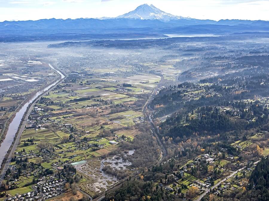
Floodplains are a limited geographic area where our values can sometimes collide. Floodplains provide rich and fertile soil for agriculture, habitat for salmon, and include important sites for flood risk reduction projects that can make our communities safer.
Communities across Puget Sound are beginning to envision and implement a new way of managing floodplains. Historically, actions to reduce flood risk were separate from actions taken to restore habitat. Many of these had no considerations for agricultural lands or uses.
Integrated floodplain management is a new form of planning, action and management where Floodplains for the Future (FFTF) partners have agreed on a set of shared visions, strategies, and actions to improve floodplain health. Instead of competing against one another for limited resources, FFTF partners work together to pursue diverse funding opportunities and develop a suite of integrated projects that collectively moves stakeholders across the watershed closer to achieving their goals.

Farms
Many of our region’s most productive farms are located in floodplain areas. Hundreds of years of sediment deposition across floodplains has built up fertile soil that helps farmers grow food to feed our communities. Agriculture is often considered a compatible floodplain use because, compared to commercial or residential development, farms have less structures at risk from flooding. But the conditions that allow farming to thrive in a floodplain area can be fragile. A healthy floodplain for farming is one in which flood impacts are not catastrophic, where fields are able to drain, and where groundwater conditions are conducive to farming.

Fish
A healthy floodplain for fish is unconstrained by levees, roads, or other barriers that limit the movement of water and nutrients. Unconstrained floodplains allow the development of side channel off-channel habitats that are important to juvenile salmon as they grow. Floodplain restoration such as levee setback projects reconnect large areas of floodplain to the main river, provide habitat diversity, and are essential to the recovery of ESA-listed salmon such as Puget Sound Chinook salmon.

Flood Risk
Flooding in the Puyallup Watershed is a function of storms and large rain events and is therefore inevitable. What we can control is the damage floods cause when they happen. From a flood risk reduction standpoint, a healthy floodplain is one that can withstand a flood event without major damage. Efforts that move or keep people, homes, businesses, and infrastructure out of dangerous floodplain areas increase our ability to weather flood events. A healthy floodplain is also one where the failure of a single component of flood management infrastructure will not lead to catastrophic results. And a healthy floodplain is one that can recover quickly from the disturbance of a flood.
FFTF Commonly Used Terms
-
Baseline year
For the purposes of the monitoring plan, 2013 will serve as the baseline year for the FPA, which is the first year of Floodplain by Design funding for the Floodplains for the Future collaboration. Changes in monitoring program metrics related to land use, farmland, habitat and other attributes of the floodplain are tracked over time from this baseline year.
-
Floodplain conditions assessment
As a proxy for floodplain function, the condition of a floodplain is assessed by its connectivity to active river channel (i.e., connected or disconnected), its land cover, and its land use. The conditions assessment divides the floodplain into four categories.
-
Floodplain extent
The approximate historic extent of floodplains that existed prior to the placement of barriers such as roads, railroads, and levees/dikes (also referred to as the geomorphic floodplain). Recent flood events have reached this extent, but future events may extend even further.
-
Floodplain health
The condition of multiple elements that when considered together contribute to a functioning floodplain, including the natural physical processes and biological factors that support salmon populations; the long-term viability of agricultural lands; and the risk of flooding.
-
Floodplain planning area (FPA)
The mapped floodplain area used for tracking changes in spatial metrics in the monitoring program. Covers low-lying areas in the Puyallup River Watershed that are adjacent to the largest river and tributary channels that can be inundated by flood water or channel migration. The FPA represents the historic floodplain that could potentially be restored (including areas within the channel migration zone and also behind levees).
-
Index of floodplain health
A composite of metrics selected for tracking progress toward shared goals for the Puyallup River Watershed arranged around three categories: investments, land, and outcomes.
-
Integrated floodplain management
A planning strategy that seeks common agreement on visions, strategies, and actions intended to maximize the benefits that floodplains provide and reduce risks facing property and life. Integrated management can lead to suites of actions that encourage collaboration between partners and meet the needs of farm, fish, and flood risk. Integrated solutions make better use of limited funding and staffing and lead to wiser capital investments.
-
Learning Cycle
Portion of the year when FFTF partners and the monitoring team use metric results (for a given year) to make connections to and between strategies and actions, take steps to adaptively manage the monitoring program, and/or take steps to adaptively manage the activities of the FFTF partners.
-
Long-term agricultural viability
The ability of a farmer or a group of farmers to productively farm on a given piece of land or in a specific area; maintain an economically viable farm business; keep the land in agricultural use long-term; and, steward the land so it will remain productive in the future.
-
Results Cycle
Portion of the year when the FFTF monitoring team issues a call for monitoring data from metric leads, receives and assembles the data for review and discussion by FFTF partners, and presents the information at the Results Summit. The Results Cycle concludes with publishing of results in an Annual Report and on the FFTF website.
-
Results Summit
An annual meeting of FFTF partners to review results from monitoring metrics and discuss implications. Typically held in May.