Financial Investments
How Are We Improving Floodplain Health in the Puyallup Watershed?
We are making capital investments in integrated floodplain management and making progress toward our goals
FFTF partners meet regularly to discuss how to best implement their vision for integrated floodplain management in the Puyallup watershed. Implementing that vision requires financial investments, and the following metrics help us understand how much we are investing, its impacts, and whether or not we are making progress towards our goals.
Combined Contributions by FFTF Partners
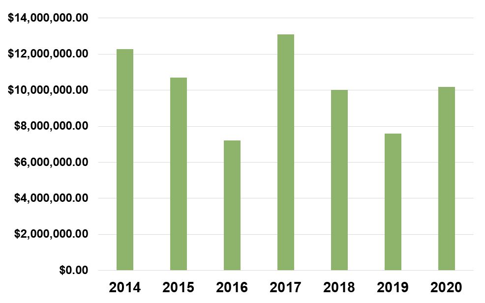
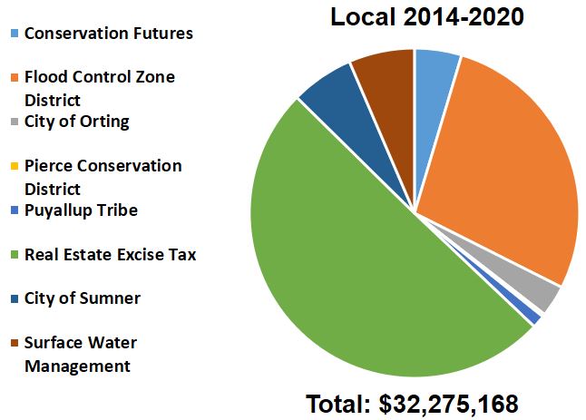
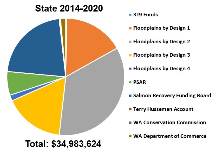
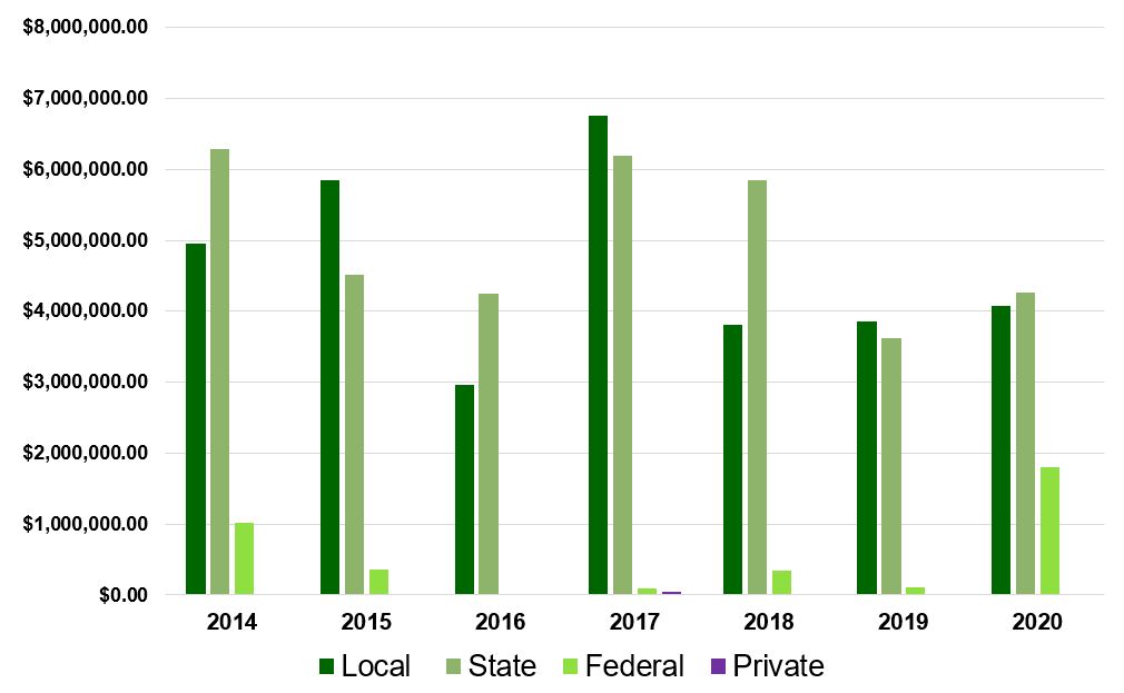
FFTF partners are working together to support the recovery of floodplain functions and protect the health and safety of communities around floodplains. Working independently and collaboratively, FFTF partners seek and acquire funding from multiple sources, including federal, state, and local grants, rate-based fees and taxes, and private foundations. Partners provide match funds in many cases and use existing grants to leverage additional funds where possible. Together, the combined investment of all FFTF efforts serves as an indicator of progress toward the shared goals of the FFTF program. In 2020, partners contributed over $10 million toward FFTF activities, bringing their total combined contributions to over $70 million since FFTF was formed in 2013.
FFTF Goal(s):
All Goals
Baseline Year:
2013 (First year of Floodplains by Design funding)
Status:
$71,060,258 total investments in integrated floodplain management
Source(s):
Includes, but is not limited to:
- Pierce County Planning & Public Works (PPW)
- Pierce County Flood Control Zone
- Pierce County Real Estate Excise Tax (REET)
- Salmon Recovery Funding Board (SRFB)
- Estuary and Salmon Restoration Program (ESRP)
- Puget Sound Acquisition and Restoration Fund (PSAR)
- Regional Conservation Partnership Program (RCPP)
- Pierce County Conservation Futures
- Pierce County Transfer of Development Rights Program (TDR)
- Private Foundations
- Floodplains by Design
- Other sources as applicable.
- 2018 Result: $10,012,107 of combined contributions by FFTF Partners
- 2019 Result: $7,580,676 of combined contributions by FFTF Partners
- 2020 Result: $10,168,320 of combined contributions by FFTF Partners; $71,060,258 in cumulative combined contributions
Restored Habitat
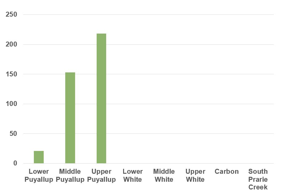
The restoration of wetlands, floodplains, and riparian areas provides important habitat benefits for fish and wildlife. This metric uses data from the Pierce County Salmon Recovery Lead Entity to track habitat restoration and reflect progress toward FFTF goals related to improving habitat. Floodplain reconnection is reported separately. FFTF partners have identified that a comprehensive system to track restored habitat is needed to capture all the restoration that is occurring in the watershed; it is likely that this metric is currently under-reporting the acres of restored habitat.
FFTF Goal(s):
- Protect existing functional salmon habitat
- Restore historic function for spawning, foraging, and rearing habitat
- Increase salmon abundance
- Improve water quality
Baseline Year:
2013 (First year of Floodplains by Design funding)
Status:
170 acres of restored habitat to date
Source(s):
Pierce County Lead Entity Coordinator with support from Pierce County Planning & Public Works staff and project sponsors
- 2013 – 2017 Result: 151 acres of restored habitat
- 2018 Result: 17 acres of restored habitat
- 2019 Result: 1 acre of restored habitat
- 2020 Result: 1 acre of restored habitat
- Total Result: 170 acres of restored habitat
Investments in Agricultural Viability
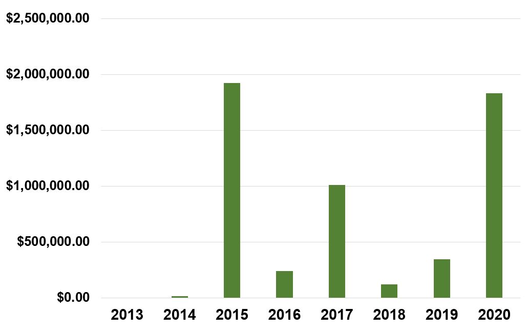
This metric tracks the financial investments made towards improving agricultural viability throughout the Puyallup Watershed. This metric only tracks financial investments, staff time is not included.
FFTF Goal(s):
- Protect/conserve agricultural lands
- Maintain viable farming economy/critical mass of farmland and farm businesses
Baseline Year:
TBD
Status:
Metric results will be collected in 2020.
Source(s):
Multiple
- 2014 Result: $15,481 contributed towards agricultural viability
- 2015 Result: $1,924,673 contributed towards agricultural viability
- 2016 Result: $239,308 contributed towards agricultural viability
- 2017 Result: $1,010,481 contributed towards agricultural viability
- 2018 Result: $120,096 contributed towards agricultural viability
- 2019 Result: $344,515 contributed towards agricultural viability
- 2020 Result: $1,833,740 contributed towards agricultural viability
- Total Result: $5,488,293 contributed towards agricultural viability
Conserved Farmland
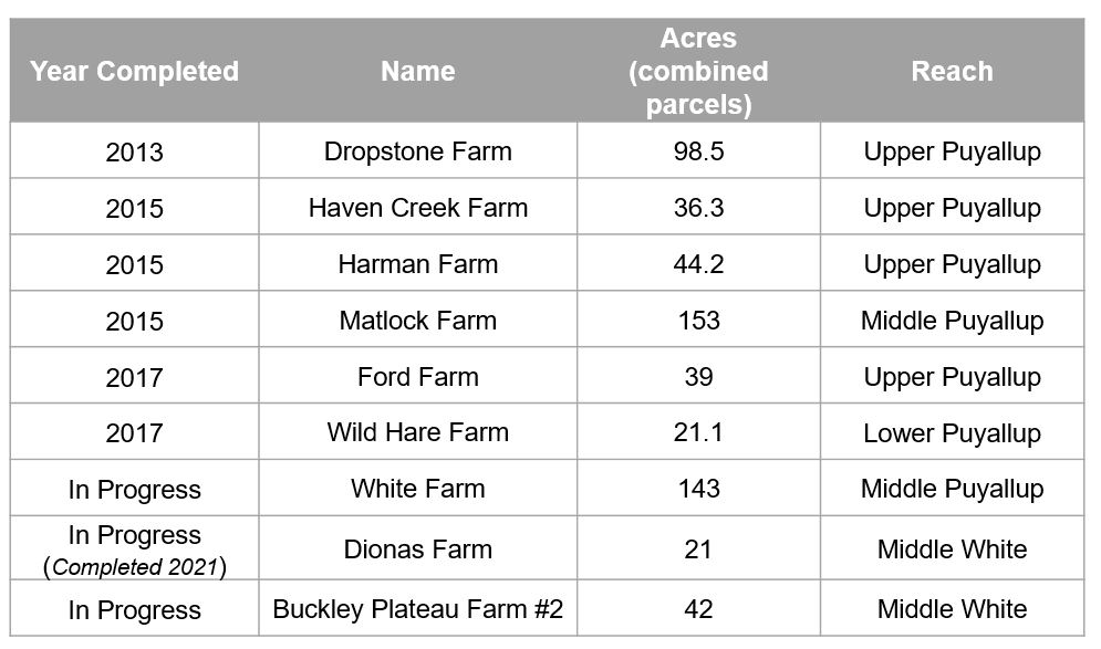
Agriculture has long been a major land use in the floodplains of the Puyallup Watershed. Compared to commercial, residential, or industrial development, agriculture is a compatible floodplain land use, and conserving a viable agricultural land base helps reduce the amount of development in the floodplain. This metric tracks the completion of farmland conservation projects carried out by FFTF partners, including Pierce County, PCC Farmland Trust, and Forterra. The total acreage of conserved farmland to-date, 393 acres, represents only 10% of actively farmed land in the floodplain planning area. Structural problems with federal partners processing easements have recently been resolved and the Strategic Conservation Partnership anticipates more projects closing in the next 2 years.
FFTF Goal(s):
- Protect/conserve agricultural lands
- Minimize conversion of agricultural lands to non-ag uses
Baseline Year:
2013 (First year of Floodplains by Design funding)
Status:
393 acres of conserved farmland
Source(s):
Pierce County, PCC Farmland Trust, Forterra
- 2013 Result: 99 acres of conserved farmland
- 2015 Result: 234 acres of conserved farmland
- 2017 Result: 60 acers of conserved farmland
- 2020 Result: 0 acres of conserved farmland, 3 projects (206 acres in progress)
- Total Result: 393 acres of conserved farmland
At-risk Structures Removed
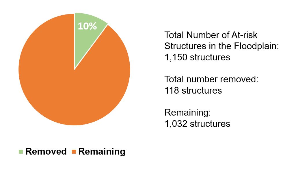
Counties and cities in the Puyallup watershed regularly identify and seek to address risks to individual structures and properties from flood damage and harm. Properties include those identified in adopted flood management plans or repetitive loss plans. Governments reduce risks by physically removing the property or structure through acquisition or providing a structural solution (such as a levee setback). At-risk structures can also be abandoned after a flood event. Results for 2020 were lower than anticipated due to impacts from the COVID-19 pandemic.
FFTF Goal(s):
- Make communities more resilient to flooding and reduce flood risk and damage to private property
- Reduce flood risk and damage to public infrastructure
- Increase the resilience of flood management infrastructure, the ecosystem, and agriculture as climate changes
Baseline Year:
2013 (First year of Floodplains by Design funding)
Status:
118 structures removed
Source(s):
Pierce County, King County, and Cities of Puyallup, Sumner, and Orting. Existing plans include: Pierce County Rivers Flood Hazard Management Plan (2013); King County Flood Hazard Management Plan (2006) and Update (2013); and City of Puyallup Hazard Mitigation Plan Update (2017).
- 2013 – 2018 Result: 103 structures removed (~17 per year)
- 2019 Result: 8 structures removed
- 2020 Result: 7 structures removed
- Total Result: 118 structures removed
Floodplain Reconnection Projects
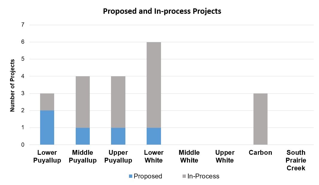
Floodplain reconnection projects are designed to reconnect floodplains to rivers and tributaries, providing room for rivers to migrate, lessening the impacts of severe flood events, and creating additional habitat. This metric tracks the total acreage of completed floodplain reconnection projects as well as the number of reconnection projects in progress and proposed by Pierce County. Floodplain reconnection projects take a long time to complete; in some years, no projects will be completed, but many projects will move forward. In some instances, benefits area realized from “in-process” projects even if construction is not fully finished.
See the Projects page for more information about individual projects.
FFTF Goal(s):
- Reduce flood risk and damage to public and private infrastructure
- Reconnect floodplain to the river (at various flow levels)
- Provide more space for the river to migrate
- Increase the resilience of flood management infrastructure, the ecosystem, and agriculture as climate changes
Baseline Year:
2013 (First year of Floodplains by Design funding)
Status:
409 acres of completed floodplain reconnection projects
Source(s):
Pierce County Rivers Flood Hazard Management Plan & Flood Control Zone District Comprehensive plan of Development (2013); Project specific information provided by jurisdictions.
- 2013 – 2018 Result: 333 acres of completed floodplain reconnection
- 2019 Result: 11 acres of completed floodplain reconnection
- 2020 Result: 65 acres of completed floodplain reconnection. 15 more projects are in progress and an additional 5 projects are proposed.
- Total Result: 409 acres of completed floodplain reconnection.
